

Explore Walks and Trails in Creeslough and find out more about the local area from historical landmarks to beautiful scenery to getting a closer look at the local farm animals from cows, sheep and chickens.
Here are some of the local walks in and around Creeslough but watch and be warned very few are flat.
enjoy the beautiful scenery along various walks in trails in Creeslough.
Duntally Wood


Nature walk in Creeslough
You can enter the woods at several points but the best walk is from the Duntally road through the woods to the N56 side. It is best to leave your car at the corner of the garden and walk down the hill to Umerafad.
The path can be joined at Duntally road and it meanders through the various trees, flora and fawn within the woodland. Once you exist at the N56 side you can assend the road back into the village. This route is suitable for pushchairs and wheelchairs.
Distance: 2.5KM
Time: 40 mins
Glenveagh National Park
Castle Path
Once parked at Glenveagh National Park, you can join the castle path from the lake. It is mostly flat with a few inclines. The main advantages is a hot cup of tea at the tea room before returning back on the same path. If you can’t walk back take the Shuttle bus back to the car park. This is a mostly gravel path and is suitable for pushchairs and wheelchairs. It can get very busy during the summer months.


Distance: 4KM
Time: 30 mins
Glenveagh Nature Walk
There are several nature walks in Glenveagh National Park. The closest to the car park is called the Derrylahan lakeside walk. You can join the path from the lake. The walk takes you through the forest on the lakeside with a beautiful view over the valley to the castle.
Once through the woods the trails starts incline. This part is very steep but makes way for another beautiful view over to Muckish from the top. We have seen many deers along this path. The Trail loops back along the entrance to the car park/National Park. It would be difficult with a pushchair or wheelchair due to the steep incline and the forest floor terrain.
Distance: 3KM
Time: 25 mins.
Muckish Mountain


Climb Muckish Mountain in Donegal
Many locals and visitors have climbed Muckish and some take part in a seven sisters challenge climbing all the mountains in 24 hours. The mountain can be climbed from a path off the R256 or by joining the old miners path. Most people ascend and descend the same path, but it can be tricky due to the uneven surface and it can take around 2.5 hours. Fog can descend quickly over the mountain so check the weather forecast for clear skies before starting your climb. READ MORE about Muckish. It is suitable for families but the surface is uneven and care must be taken.
Burtonport Railway Trail

Historical Railway walk and trail
You can join the Burtonport railway trail at Muckish Mountain. The trail is a flat trail which takes you to Falcarragh. This historical path follows the old railway line long since gone. It passes along Lough Achair in Kildarragh and is general flat with some slopes and descents. It is suitable for all the family. This walk and trail in Creeslough is of historical significance as it follows the old Burtonport Railway line now long gone.
Distance; 9.4KM
Time: 2 hours.
Two Lakes loop: Lough Natooey to Rooskey Lake

Nature walk in Creeslough
Explore the townlands of Creeslough and take a countryside walk along to Roosky lake. Starting from the Roosky road walk up through Ballyboes, Roosky and Craig. This is largely uphill with two steep hills. Once at the top of Craig there is a great view over the Lough Natooey out towards Ard Estuary. On the descent from Craig there is a pathway off the road to the lake, where you can get a picture perfect view of the lake and Muckish mountain.
Staying on the road walking down hill towards Ballyboes and Roscad you will join the N56. Walking along the main road you will then pass Lough Natooey on the left. Then there is a final assent back up to the Roosky road.
Exploring Walks and trails in Creeslough is a great way of meeting locals or seeing some of the farm animals from cows, sheep to chickens.
Distance: 5.7Km
Time: 50 mins
Ards Nature Walk


Locally recommended trails
There are several walks in the Park ranging from coastal paths, to hilly inclines which maybe difficult with a pushchair. The best for pushchairs or wheelchairs is the marine walk along the boardwalk. The Walk to the viewing lookout is also worth it as the views over to Ballymore are beautiful. Getting out on the many walks and trails in Creeslough is a great way to get in touch with nature.
Distance: various walks
Time: 1-2 hours
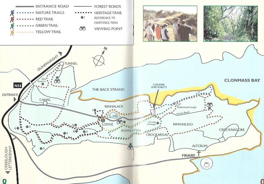
Ards Heritage Trail.
This trail commences at the lodge in the forest park and proceeds Northwards to Caisel Lily and back to the lodge. Along this trail there are several significant heritage stations. Caisel Lily is the best example of a prehistoric ring fort in the park. There are 4 ring forts in Ards. The lodge once a gatehouse for the Ards Estate was built in 1900s. The mass rock where mass was celebrated during penal times. There is also a holy well were emigrants were said to visit before emigranting. the holy water is said to have the cure of either loneliness or malaria. Conynghan’s Rock which legends says was wer Captain Conynham a Cromwellian officer at Doe Castle was said to have been killed. Medal Hill where Father Theobald ‘the Apostle of Temperance’ administered the temperance pledge in 1841. And Grainne and Diarmuids’ Bed. The site is said to be were Diarmuid and Grainne lay whilst fleeing the wrath of Fionn MacCumhaill.


Distance 3.5KM.
Time 1 hour.
Ards Friary Walk.
This mostly gravel trail starts along the shore just below the Ards Friary. The walk is flat is lined with large conifer trees until you reach the first beach called Lady Elizabeth, named after the former heiress of the Stewart Ban Estate. There are several benches and the sandy beach is a nice break to stop at before returning back to the Friary.
The path continues to follow along the coastline until you reach a small opening/gate. Once through the gate the path is gravelled but undulating. This path can be followed all the way to the next beach called Lucky Shell. Whilst the tide is out you can walk along this beach and around the coastline into the car park in Ards Forest Park. It is best to check tide times before attempting the walk around to the forest Park.


Distance: 1.5KM – 5KM.
Time: 35Mins.
Magherablade to Umerafad loop
Explore Walks and trails in Creeslough through the Townland of Umerafad and Magherablade.
Starting from the corner of the garden walk down through the town and take the road to Magheroarty. There is a gradual descent until the road turns right and starts to ascend up to Umerafad. There is a small descent until a final hill back up to the village. This is a good family walk along a quiet road. It is suitable for Pushchairs and Wheelchairs.
Distance: 5KM
Time: 50 mins
Laracus/Errigal Forest Walk


This woodland path can be accessed off the R256 road from Glenveagh enroute to Falcarragh. The road leads from Muckish to Errigal through Fir lined trees some young to more mature. The woodland path is mostly flat and is suitable for pushchairs and would be ideally for cycling. There are also several trails of the main route. You will hear lots of birds chattering in the trees and the continuous running of the many brooks and streams make it a tranquil setting. There is limited parking at the entrance.
Drimnacarry to Drimnaraw Cross Roads Loop walk.
This country road is a peaceful and scenic walk. Starting at Drimnacarry there is a small space to park the car of the road (L5242). The views from the walk are of Muckish mountain to the south and the Derryveagh Mountain range the North aswell as out towards Glenveagh. From the road there is also a fantastic view over toward the Viaduct and the Owencarrow River Memorial. The Road comes to a fork at 1.5Km and to stay on the looped walk – keep left. This road then loops down through Creenary. The Creenary Mass Rock is only a short walk off this road. Take a left instead of going over the Bridge at the end of the road. This road then takes you past the Owencarrow Viaduct Memorial. Once at the Drimnaraw crossroads take left towards Creeslough. You will have to walk along the N56 so extra caution is needed.
Distance: 5KM
Time: 45 minutes.


Drimnaraw to Lackagh Bridge


Owencarrow river walk
This is a 2km walk starting at the Log Cabin. The walk is quiet as it meanders through bog land past several homes. Before joining the inland fisheries road to Glen Lough. The walk starts from the Derryfad road (maybe leave car at the Log Cabin but be careful walking along the N56).
There is a lovely river side walk to Glen Lough with a picnic table along the way. Very quiet place to meander. Suitable for all as on a country road/tarmac. Not a look walk so you’d need to turn when you reach the jetty entrance to Glen Lough.
Distance: 2km
Time: 30mins.


